

Future Of Drones Starts in Daytona
Start a game-changing career working with dynamic drone technology or just get involved in the "Excitement and RUSH" of drone flying competition. Drones are breaking barriers in the way companies do business. Unlike any other remote control model hobby, Quadcopters are a revolution because of their utility. From Industry innovation, to an exciting hobby, the use of drones has rapidly changed over the past years —The future opportunities in the field are limitless. It all starts Here in Daytona Beach, The gateway to Quadcopter development, Industry Innovation, and Lots of Safe Flying Fun!
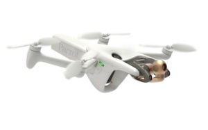
Daytona Drone 'Rooster'
An Integrated Solution for Autonomous Commercial Drone Inspection.
Sometimes you just have to do it yourself. Our in-house 3d printed drone incorporates seeker technology and is GPS Denied capable. We call this merging of 3d printing and bleeding edge tech 'Rooster', and yes it's got 4G Cellular communications.


Daytona Drone Club
Sponsor A Drone Pilot
You can get involved in our communities by sponsering a drone pilot. So many youth are looking for ways to get involved in technology but the cost sometimes is the roadblock.
Help us Help them get their hands on a New And innovative technology. Yes it’s Drone flying!
We can get a potential drone racer working out and learning the many scientific elements of aviation by getting them involved in Drone flying
PILOT Training
Pilot training using several drone types from light agile mavic to larger 6 motor models.
Daytona Drone Pilots accomplish regular flight training comprised of techniques learned from actual missions. Our training objective is to provide constant feedback from missions to help develop challenging training courses, continually changing, adding elements that push pilot skills and form habits for safety and production. This includes continued studies in Autonomous applications, programming, and post-mission analysis.
Flight Review. FAA Part 107 certificate doesn’t require a flight review but we offer instruction that meets AUVSI Top level2 certification
Drone Flight Training. Hands-on flight training. Get critical training, flight hours, and prepared for an actual Drone Flight Review
Ground School direction and examples to prepare for the FAA part 107 exam to acquire your Drone Pilot Certificate.
![]() We work incorporating Top Protocols and training outlines
We work incorporating Top Protocols and training outlines

Inspections
An Integrated Solution for Autonomous Commercial Drone Inspections.
Precision Agriculture
See growth trends, count and size plants, identify early indicators of plant stress, generate prescription maps, and measure the
zonal efficiency of your farm. Automatically generate georeferenced orthomosaics from data collected using drone-compatible sensors,
including visual (RGB), 3-Band multispectral, and thermal, made by Parrot Sequoia, MicaSense Red Edge M/MX, and
MicaSense Altum.
Get access to a continually expanding library of professional, on-demand farming analysis tools to gain the critical insights you want, when you need them.
More time-efficient operations, enabling decision-making in days instead of weeks
Calculate aggregated statistics on an area-by-area basis—from large zones to small plots—and export statistics for each one. Quickly define plots using an instant grid tool and refine boundaries in an intuitive point-and-click interface. analyze trends in crop growth.
Map 200 acres in 15 minutes without the need for cell connection or internet access
Examine crops with Plant Health Live Map and immediately ground truth your findings using GPS navigation
Visualize temperature range variability and generate thermal maps over large areas with Thermal Live Map
Share a Live Stream of drone footage directly with your team to respond to emergencies or conduct remote inspections
See an archive of all your crop analytics throughout the growing season, from planting to harvest, or compare data across multiple growing seasons. In agriculture, one big benefit of drone inspections is improving crop yield.
Data collected by drone can be used to ensure that crops and soil receive exactly what they need for optimum health and productivity, a practice that has been named precision agriculture.
Visual crop data in a quick flight that might otherwise take hours of walking
Drone data can also be used to provide a record of crop health over time, allowing farmers to compare crops from one year to the next or across seasons in order to optimize their yield in various conditions.
Mapping and Surveying
Drone surveys are revolutionizing the construction industry. Improved quality and safety, combined with nearly instant access to survey data and imagery, can help protect your project’s budget and schedule — and ideally help you reduce both.

Drone Shots
Let’s Fly or Not!
As with alot of developing technologies getting accepted can be difficult. The general population at this point has not accepted Small fast drones and with that neither have the local governments. Daytona Drone has tried and failed to get permission and location for this exceptional hobby and learning experience. Because of this we abandoned our efforts until a more favorable environment happens
No Defined Areas
We are working to establish a drone recreational area in Volusia. Please contact for more details.
SUBSCRIBE TO OUR NEWSLETTER
For Latest News And Updates Through Email.
[mc4wp_form id=”393″]